|
Benefits for Research and Technology
The following fields are expected to benefit from the outcome of BALTEX:
- Short range weather prediction
- Medium and long term climate prediction
- Climate monitoring and impact studies
- Observational techniques and networks
- Water resource assessment
- Water resource management
- Environmental studies and monitoring
|
|
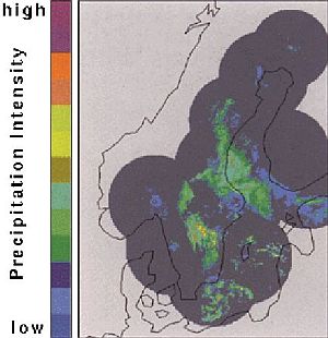
Remote sensing data from radar will provide essential information for areal survey of a variety of atmospheric and surface properties ( e.g. Sea Surface Temperature) and processes in the BALTEX area. The image depicts precipitation from NORDRAD weather radar network showing a situation on December 11, 1993. Spatial coverage of NORDRAD is covered dark (by courtesy of NORDRAD) |
|
|
BALTEX, as a research programme integrating three disciplines into one single project, will be mutually stimulating and is expected to overcome traditional embarassing barriers between meteorological, hydrological and oceanographic research.
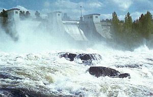
Human activities may change natural water cycles,at least at local to regional scales.
Hydro-electric powerplant in Sweden (by courtesy of SMHI, Norrkoeping, Sweden)
|
|
|
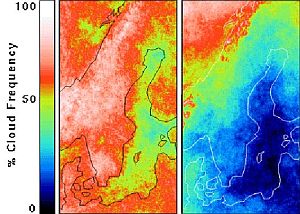
Remote sensing data from satellites and radar will provide essential information for areal survey of a variety of atmospheric and surface properties and processes in the BALTEX area.
Cloud frequencies for July 1993 (left)and July 1994 (right) derived from NOAA-AVHRR, indicating year-to-year and regional variability of cloudiness (by courtesy of SMHI, Norrkoeping, Sweden)
|
|
|
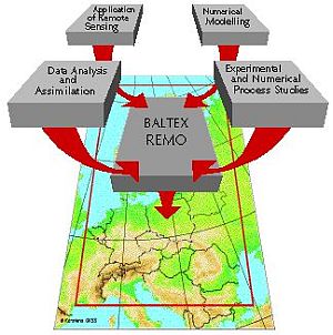
Different versions of regional-scale models, which have been originally developed for operational weather forecast purposes (such as the nordic HIRLAM or the Deutschland model of the German Weather Service) will be coupled to hydrological and oceanographic models in order to develop a comprehensive, fully coupled model as a central analysis and forecast tool.
|
|
|
More background
|
|
 |
|
BALTEX Phase I Achievements
More...
|
|
International Cooperation
More...
|
|
BALTEX Phase II Prospects and objectives
More...
|
|
The Baltic Sea catchment basin
More...
|
|
Water and energy cycles in the climate system
More...
|
|
|
|
|